Introduction
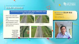
With our autonomous UAV systems, we can effectively reduce many high-risk and high-cost inspections which require high manpower, such as inspections of dams, river, coastline patrols, etc.. Operators only need to setup and launch the system to allow the UAV to complete the designated tasks independently. The UAV will fly autonomously through visual navigation, and will detect, record, measure and mark the specified objects accordingly, while updating information to the satellite aerial image using spatial positioning technology, so that stakeholders can have a more comprehensive understanding on overall situation.
This technology integrates different technical modules through a decision model and verifies it in a real environment, to test verify that our autonomous UAV system can complete inspection tasks independently. This technology closely combines visual perception and flight control. In order to improve instant response, the visual model is lightened. Combined with spatial positioning technology, it can provide more accurate object positions; compared to other drone research, we focused more on solving real-world environment issues, which provides sufficient index to support robustness.
This technology can effectively supplement the manpower and data requirements for inspections, assist them to update facility information regularly and more comprehensively at relatively low costs and risks, and support decision-making in resource distribution. This technology is not only suitable for inspection-related tasks, but also provides new solutions for different industries. Through the images provided by drones, it can provide decision-making information in different situations, such as: UAV signal base station, high-speed rail detection, object delivery.